- Maritime
- Photonics & Space
Improving natural hazard risk management in one of the most active European seismic and volcanic region


In the framework of several research projects with major European partners, Exail has been deploying state-of-the-art Earth Monitoring technologies in the Sicilian region. Across the North Alfeo Fault, near Stromboli and Etna volcanoes, the region hosts an urban area with a population of one million. Exail technologies, which include seafloor geodetic stations, volumic sonars, rotational seismometers and quantum gravimeters, are crucial to help improve seismic and volcanic surveillance of such a sorely tried region.
Monitoring active seafloor fault at the foot of the most active European volcano with Canopus transponders
The South Sicilian region already suffered very destructive earthquakes (more than 70,000 deaths at the beginning of the last century). It is thus fundamental to better understand seismic processes in action and plan the surveillance of movement along the North Alfeo Fault, located at more than 2,000 m under the water surface at the foot of Mount Etna. Moreover, the fault is itself connected to a network of faults, acting like dominoes. The FocusX3 mission1, 2 started in February 2023 with the goal to better understand the tectonic displacements and movements of deep waters in the area.
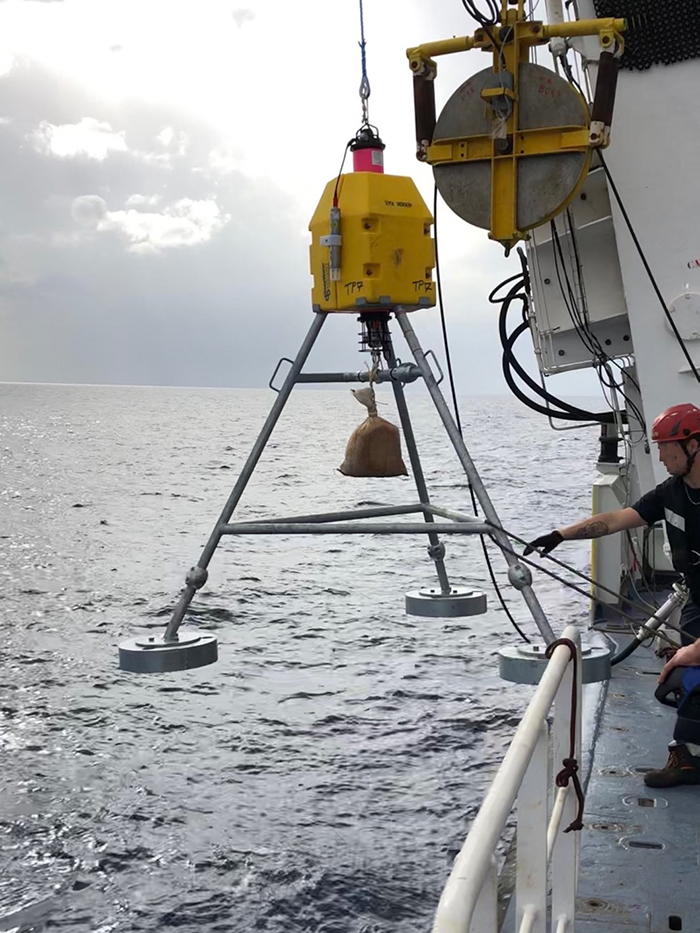
To acquire a firmer understanding of the fault system—which stretches over 100 km, from the coast at the foot of Mount Etna to the southeast—scientists deployed a 6-km fiber-optic cable that measures fault movements with laser interferometry (BOTDR method). During the FocusX3 mission, the research crew deployed new instruments, including 8 new seafloor geodetic stations (Exail’s Canopus). An Exail support engineer assisted the scientific team in the implementation of these Canopus transponders, which are acoustic instruments with communication capabilities. They will measure the relative displacement in “3D” of tectonic blocks on either side of the fault with a centimeter scale resolution, and confirm the displacement observed with the BOTDR method. Deployed on purpose to provide the best acoustic coverage after using the Array Planning module of Delph Subsea Positioning software developed by Exail, the Canopus are equipped with ancillary sensors (inclinometer, sound velocity and pressure) to monitor subtle changes near the sea-bottom. Combined with the measurements from an external high-precision temperature probe, all data will be collected continuously (sampled), stored on an internal memory card then uploaded periodically (every 6 months) by a surface transceiver using the acoustic communication capability (modem) of Canopus beacons.

“We needed a highly accurate and reliable system able to provide precise measurements over many years” explained Jean-Yves Royer, in charge of the project at the European Institute for Marine Studies (IUEM). “The autonomy provided by the Canopus transponder, along with its ease-of-use and the availability of the Exail teams during the tests phase were decisive factors in our choice of transponders for this major project.”
Marc-Andre Gutscher (CNRS researcher at Geo-Ocean laboratory – IUEM), FocusX3 project leader, was very enthusiastic with the first results offered by the Canopus after the February 2023 mission “We are happy with the support of Exail’s engineer Gregor Jamieson, who was onboard during the FocusX3 to assist during preparation and deployment. The first tests he performed showed that the communication with beacons as well as the data loading rate are excellent.”
The 8 Canopus transponders, deployed for the geodetic network of the Focus project, are integrated monitoring systems deployed for a period of 3 to 5 years. Enhancing Exail’s offer in subsea positioning solutions, the Canopus LBL transponder was developed in tight collaboration with major scientific partners. Easy to deploy and to use thanks to its user-friendly MMI (Man-Machine Interface), it is especially suited for scientific and industrial applications that require high autonomy, instrumentation, repeatability and accuracy.
Rotational seismometer BlueSeis demonstrating its seismology and volcanology capabilities on Stromboli volcano
On the other side of Sicily, the volcano on Stromboli Island, one of the most active volcanoes in Europe was the field of several evaluation missions in 2016, 2018 and 2022, for the demonstration of the interest of 6 degrees of freedom (DOF) computation (3 axis on translation + 3 axis on rotation) on seismology and volcanology. With the assistance of the Exail support team, 3 blueSeis-3A were collocated with 3 classical translational seismometers to record local events on the Stromboli volcano. The field observations involved Laurent Mattio (Exail), Joachim Wassermann and Felix Bernauer (LMU) and Thomas Braun (INGV).
Based on Exail’s expertise in the design and manufacturing of Fiber-Optic-Technology (FOG), blueSeis-3A is revolutionizing the seismology research community. By measuring the rotational movements (yaw, pitch and roll) of the ground, it allows for a complete measurement of the seismic wave. By using light for the measurement, the Fiber-Optic-Technology is entirely insensitive to linear accelerations and no cross coupling can happen. BlueSeis-3A is today the best and most reliable rotational seismometer with 3-axis, low-noise, broadband, high dynamic range and flat passband solution with “geosciences-ready” interfaces including heading and time stamping.
“With the advent of new instrumentation based on fiber optic technology such as Distributed Acoustic Sensing (DAS) with fiber optic cables as well as Fiber-Optic Gyroscopes the measurement of deformation and rotation, i.e., the gradient of the wavefield is feasible.” Joachim Wasserman (LMU) in Journal of Volcanology and Geothermal Research (Feb. 2022)
“We show that with this new six-degrees-of-freedom (6DOF) measurement we are able to analyze the wavefield composition, a property normally reserved for array(s) of seismic sensors.” said Joachim Wasserman in JGR Solid Earth (May 2022) and at EGU2022.
SeapiX, a volumic 3D sonar to help better understand volcanic activities
In collaboration with Corentin Caudron, volcanologist-geophysicist at Université libre de Bruxelles (formerly ISTerre – France), the SeapiX volumic 3D sonar was mobilized in late 2022 to image underwater volcanic environments at Panarea island, near Sicilia. Panarea is a caldera, a depression with a flat bottom following a large eruption, located off Stromboli. The volcano experienced a hydrothermal eruption nearly 20 years ago. A connection with the magma reservoir feeding Stromboli is even possible, according to a study by local researchers from the Italian INGV.
It is crucial to accurately map bubble clouds in aqueous environments and their evolution through time to monitor volcanic risk. Overall acoustic detection of a bubble field is easy, while its quantification remains complex due to the 3D structure of clouds, heterogeneous bubble sizes and acoustic interactions between them. The Exail’s SeapiX, a 3D multibeam echosounder allowing quasi real-time coverage (120° x120° with 1.6° resolution), has demonstrated its unique capabilities to image underwater volcanic degassing in the past few years.
INGV has installed an underwater observatory in Panarea, making it an interesting place to compare different instruments. During the 2022 mission, 4 hydrophones and an Ocean Bottom Seismometer (OBS) were deployed together with static measurements using Exail’s Seapix split-beam echosounder (downward looking). Geochemists could sample fumaroles at different depths and measure the temperature, dissolved CO2 and conductivity. The data collected with ISTerre, Université libre de Bruxelles & INGV will help to understand how volcanic seepage activity can be monitored.
Ongoing research of bubbles on another volcanic lake (Laacher See, Eifel, Germany) suggests Seapix can detect bubbles of very small size (35 μm), much smaller than observed elsewhere using single beam echosounders, which were not observed using a camera mounted on ROV. Using the steerable capability of the system, performing a 4D monitoring of gas bubbling of a single gas plume, in a static position raises new perspectives to anticipate the tipping point of a critical enhancement of gas release and to mitigate the volcanic risk.

The first application of quantum technology to volcano monitoring on Mount Etna
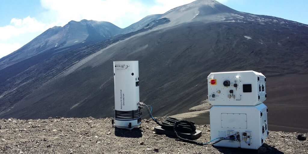
In August 2020, Exail’s Absolute Quantum Gravimeter (AQG) was installed in the summit active area of Mt. Etna, in the frame of the NEWTON-g project, funded through the H2020 program of the European Union, to test its potential as an instrument for volcanic monitoring. Since then, the AQG has performed near-continuous gravity measurements and, in summer 2022, Exail and INGV presented a four-month time series of gravity data in a peer-reviewed journal of the American Geophysical Union (L. Antoni-Micollier et al., Geophysical Research Letters).
The gravimeter was installed at about 2.5 km from the active craters of Mt. Etna and produced continuous high-quality data, despite the unfavorable environmental conditions (lack of electricity, severe temperature changes, presence of dust and corrosive volcanic gases) and the high level of volcanic tremor.
“The AQG, installed in the summit crater zone of Mt. Etna, has provided a gravity time series free from the instrumental issues which affect other gravimeters. Even under unfavorable environmental conditions, it has been possible to detect small gravity changes over different time-scales, reflective of volcano-related underground mass changes” says Daniele Carbone, senior researcher at INGV and co-author of the paper.
“Mass redistributions occurring below the Earth’s surface, for example when magma is displaced through the feeding system of an active volcano, may induce tiny changes in gravity over time, which can be detected by our AQG” explains Vincent Menoret, R&D Manager at Exail Quantum Sensors and co-author of the publication.

1 With Marc-André GUTSCHER from GEO-OCEAN lab (European Institute for Marine Studies – IUEM) as Chief scientist, the FocusX3 project involves scientists from the CNRS, IFREMER, and Université de Bretagne Occidentale (UBO), together with their German and Italian colleagues. Following the FocusX1 and FocusX2 missions, FocusX3 oceanographic expedition took place in February 2023 off the Sicilian coast. Funded by an ERC Advanced Grant over 5 years, the goal of FOCUS (Fiber Optic Cable Use for Seafloor studies of earthquake hazard and deformation) is to develop and test a new technique to monitor seafloor deformation through use of fiber optic cables in order to improve hazard assessment and increase early warning capability.
2 Learn more about recent updates with talks of J.Y Royer (Active Strike-Slip Fault Monitoring Using Marine Geodesy, Offshore Mt Etna, Sicily (Italy)) and M-A Gutscher (Monitoring a submarine strike-slip fault, using a fiber optic strain cable) at EGU 2022


